Middlebury Day Hikes
Hiking opportunities in & around Middlebury, VT

One of the best ways to get out and enjoy the beauty of Vermont at almost any time of year is to go for a hike. There’s something calming and invigorating about spending time in the woods, either alone or with friends. Here are a few great hikes in and around Middlebury to help you relax and recharge to take on whatever life throws at you when you’re not on the trail.
Map of trailhead locations (some approximate)
Abbey Pond Trail – a 4.2 mile round trip hike to Abbey Pond with a waterfall along the way in the Green Mountain National Forest. 1,200 feet of elevation change, an estimated 3-4 hour hike.
Google Map (trailhead)
Burnt Hill Trail – a 4.2 mile round trip to the Breadloaf Wilderness. The first mile is an easy climb along logging roads; the remainder of the trail is steeper through the Breadloaf Wilderness and ends at its junction with the Long Trail. Boyce Shelter is .6 miles north on the Long Trail from the Burnt Hill Trail junction. 1,280 feet of elevation change, an estimated 3-4 hour hike.
Google Map (trailhead, approximate)
Skylight Pond Trail – a 5.2 mile round trip to the Breadloaf Wilderness with Long Trail access, a pond, streams, and views. 1,480 feet of elevation change, an estimated 3 ¾ – 4 ¾ hours round trip.
Google Map (trailhead)
Silent Cliff Trail – a spur trail off the Long Trail to Silent Cliff and Silent Cave, with good views of Middlebury Gap, Monastery Gap, and the Green Mountains. 400 feet of elevation change, 1.6 miles round trip, an estimated 1 – 1 ¾ hours round trip.
Google Map (cliff)
Google Map (trailhead)

Moosalamoo Area Trails – Over 70 miles of trails are available for hiking in the Moosalamoo National Recreation Area with trailheads in Hancock, Goshen, Salisbury, Ripton, and Brandon, all about a half hour drive from Middlebury. The trails are generally day hikes but many connect to the Long Trail to allow for longer wilderness adventures if desired. A variety of trails are available for hikers of all abilities, including the Silver Lake Area trails, which offer good views and lake access. Camping available through Columbus Day.
Texas Falls Recreation Area – waterfalls and gorges accessible along an easy loop trail with a picnic area. 1.2 miles, average 1 hour hike time, 70 foot elevation change.
Google Map
Bomoseen State Park – offers a variety of easy to moderate hiking trails, including a trail to Half Moon Pond.
Trail listing on Trailfinder
Google Map
Branbury State Park – sits on the eastern shore of Lake Dunmore and offers a sandy beach, hiking trails up to cliffs and connector trails to waterfalls. Easy to moderate trails.
Trail listing on Trailfinder
Google Map
Button Bay State Park – easy, kid friendly hikes along Lake Champlain.
Trail listing on Trailfinder
Google Map
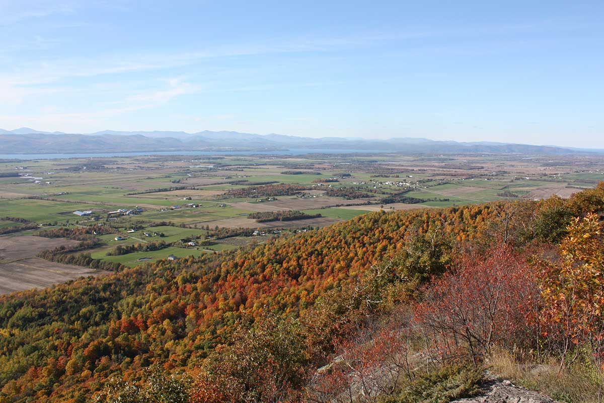
Mt. Philo State Park – climb the 968’ Mt. Philo for spectacular views of the Lake Champlain Valley and the Adirondack Mountains. ¾ mile trail or access road to the top.
Google Map
Trail Around Middlebury (TAM) – these trails loop around Middlebury and are broken into 10 sections ranging from .6 to 4.6 miles, some of which are kid and stroller friendly. The entire loop can be completed in a single day, if you’re ambitious enough!
Section Maps and descriptions
Mount Independence – a Revolutionary War historic site with six miles of trails around the archeological remains of the fortification. Features Vermont’s longest universally-accessible trail. A must-visit for history buffs!
Trail Map
Google Map

Snake Mountain – a moderate 5.1 mile loop with views of the Adirondacks at the summit – the highest point in Addison County. Descent goes past Red Rock Pond. The trail up follows a former stage coach road used to access the Grand View Hotel, which burned down in 1925.
Trail Map & Info
Google Map
Deer Leap Mountain/Bristol Cliffs – not to be confused with the Deer Leap Trail in Killington, this 3.5 mile round trip route takes you to a scenic cliff overlook where you can look down on the village of Bristol and the Champlain Valley. Find parking in downtown Bristol and head up Mountain Terrace to find the trailhead.
Did we miss any trails you’d recommend in and around Middlebury? Let us know!
Resources:
Green Mountain National Forest
Moosalamoo National Recreation Area
Vermont State Parks
Green Mountain Club – Breadloaf Section
Trailfinder
Hiking Project